Key Attractions in the Everest Region
The Everest region isn't just about reaching the summit; it's a journey through some of the most breathtaking and culturally rich places on earth. Whether you're trekking through lush valleys or high mountain passes, the region offers more than just a path to the top. Here's a closer look at three must-see spots: Sagarmatha National Park, Namche Bazaar, and Tengboche Monastery.
Sagarmatha National Park
Sagarmatha National Park is a UNESCO World Heritage site that is home to Everest and many other Himalayan peaks. But it’s not just about the mountains. This park is rich in flora and fauna that thrive at high altitudes.
The park’s forests are filled with rhododendron, birch, and juniper trees. As you ascend, these give way to alpine meadows and finally to the glaciers and snowfields near the highest peaks. Wildlife is diverse too, with species like the snow leopard, Himalayan tahr, and red panda calling the park home. Spotting these animals is rare but adds a special touch to any trek.
Sagarmatha National Park is crucial for conserving the natural beauty and biodiversity of the Everest region. Trekkers are encouraged to follow strict guidelines to protect the environment. This includes respecting wildlife, sticking to established trails, and minimizing waste. Permits are required to enter, which helps fund these ongoing conservation efforts.
Namche Bazaar
Namche Bazaar is more than just a resting point on your way to Everest Base Camp—it’s the cultural and economic hub of the Khumbu region. Located at 3,440 meters, it’s the place where trekkers acclimatize, shop for supplies, and soak in the local culture.
Namche is where Sherpa culture comes to life. The town is known for its bustling markets where you can find everything from trekking gear to local crafts. It’s also a place to connect with the Sherpa people, who have lived in these mountains for centuries. Their role in the trekking industry is crucial, providing services as guides and porters.
Beyond the markets, Namche offers some incredible views. A short hike above the town gives you your first proper glimpse of Everest and surrounding peaks. Museums dedicated to Sherpa culture and Everest history add to the experience, offering insights into the lives of the people who make these mountains their home.
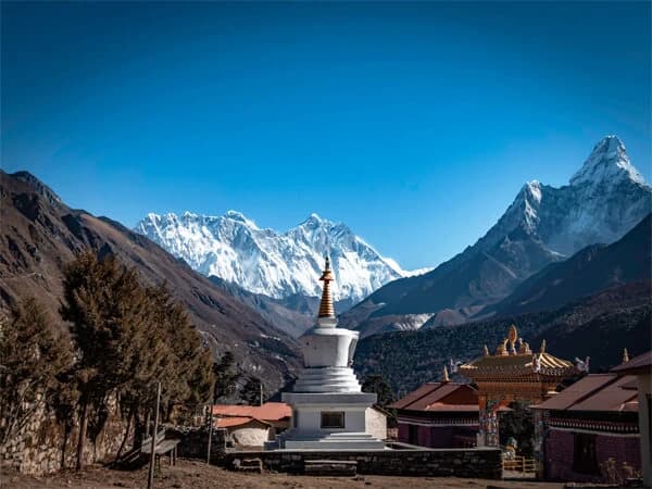
Tengboche Monastery
Tengboche Monastery is the spiritual heart of the Everest region. At an altitude of 3,867 meters, this Buddhist monastery offers trekkers a moment of peace and reflection amidst their journey.
The monastery is over a century old and holds deep spiritual significance for the Sherpa community. It’s the site of the annual Mani Rimdu festival, where monks perform traditional dances and rituals to honor the spirits of the mountains. This festival is a major draw for both locals and trekkers.
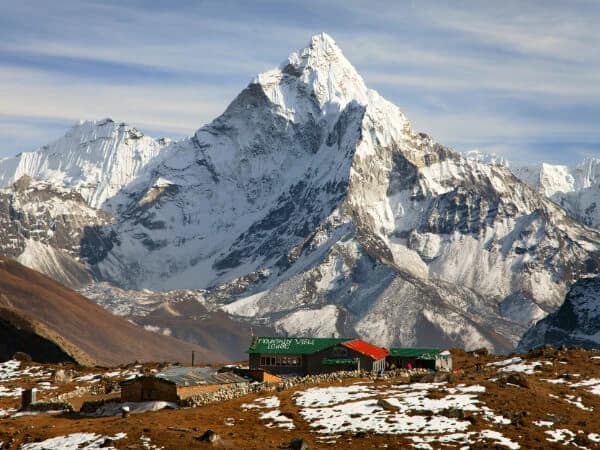
Visiting Tengboche Monastery is a serene experience. The monks welcome visitors to observe their prayers, and the surrounding views of Ama Dablam and Everest add to the tranquility. This stop is not just about the spiritual—it's also one of the most picturesque locations in the region, perfect for reflection and photography.
Everest Region Trekking Packages Options
Whether you're aiming for the famous Everest Base Camp or exploring less-traveled routes like the Gokyo Lakes or Three Passes Trek, each package is designed to give you a unique experience. These treks cater to all levels of trekkers, from seasoned hikers to first-timers looking to challenge themselves in the Himalayas.
Each package includes essential details like difficulty level, duration, and key highlights, so you can easily choose the trek that fits your interests and abilities. Whether you're after breathtaking views, cultural immersion in Sherpa villages, or the thrill of high-altitude trekking, there's a package for you.
Top Treks in the Everest Region
|
Trek
|
Overview & Highlights
|
Difficulty Level & Duration
|
Best Time to Trek
|
|
Everest Base Camp Trek
|
Classic trek to the base of the world's highest peak.
|
Moderate; 12-14 days
|
March-May, September-November
|
|
Gokyo Lakes Trek
|
Stunning turquoise lakes and panoramic views of Everest.
|
Moderate to challenging; 12-15 days
|
March-May, September-November
|
|
Three Passes Trek
|
Ultimate adventure covering three high-altitude passes.
|
Challenging; 18-21 days
|
March-May, September-November
|
|
Everest Panorama Trek
|
Short trek with spectacular views of Everest and Ama Dablam.
|
Easy to moderate; 7-10 days
|
March-May, September-November
|
|
Everest Cho La Pass Trek
|
Thrilling trek combining Everest Base Camp with crossing the Cho La Pass.
|
Challenging; 17-19 days
|
March-May, September-November
|
Essential Trekking Information
Trekking in the Everest region is an adventure of a lifetime, but it’s crucial to be well-prepared. From altitude sickness to permits and the best time to go, understanding the essentials can make your journey safer and more enjoyable. Let’s break down the key information you need before setting off on your trek.
Altitude Sickness and Acclimatization
Altitude sickness, or Acute Mountain Sickness (AMS), can affect anyone trekking in the Everest region. It usually kicks in above 2,500 meters and can lead to serious health issues if not managed properly.
Common symptoms include headaches, nausea, dizziness, and fatigue. These symptoms can escalate quickly, so it’s essential to recognize them early and act.
Acclimatization is your body’s way of adjusting to the lower oxygen levels at high altitudes. The best strategy is to ascend slowly and include rest days in your itinerary. A general rule is to “climb high, sleep low,” which means trekking to a higher altitude during the day but sleeping at a lower elevation.
Rest days aren’t just for catching your breath—they’re critical for acclimatization. These days allow your body to adjust to the altitude and reduce the risk of AMS, keeping you healthy and strong for the challenges ahead.
Permits and Regulations
To trek in the Everest region, you’ll need to secure the right permits. These aren’t just formalities; they are crucial for your safety and help fund the conservation efforts in the area.
Types of Permits Required (TIMS, Sagarmatha National Park)
You will need two main permits:
- TIMS Card (Trekkers’ Information Management System): This tracks trekkers in the region and is required for safety reasons.
- Sagarmatha National Park Permit: This is necessary to enter the Sagarmatha National Park, where most Everest treks are located.
Permits can be obtained in Kathmandu or Lukla. The process is straightforward—just bring your passport, a few passport-sized photos, and cash for the fees.
The TIMS card costs around $20, and the Sagarmatha National Park Permit is about $30. Be sure to carry extra copies of your passport and photos, as they might be required during your trek.
Best Time to Trek in the Everest Region
Choosing the best time to trek can make or break your experience. Weather conditions in the Himalayas are extreme and can vary dramatically by season.
The best seasons for trekking are pre-monsoon (March to May) and post-monsoon (late September to November). These months offer clear skies, stable weather, and the best views of the mountains. Winter treks are possible but come with challenges like snow-covered trails and freezing temperatures.
During peak seasons, popular routes like Everest Base Camp can be crowded, and lodges may fill up quickly. If you prefer quieter trails, consider trekking during the shoulder seasons.
Pros and Cons of Different Trekking Seasons
- Spring (March-May): Mild temperatures, blooming rhododendrons, but more crowded.
- Autumn (Sept-Nov): Clear skies and stable weather, but popular routes can be busy.
- Winter (Dec-Feb): Fewer crowds, but harsh weather and potential trail closures.
- Monsoon (June-Aug): Lush landscapes, but rain, leeches, and obscured mountain views.
What to Pack for an Everest Region Trek
Packing smart is essential for a successful trek. The right gear can make the difference between a comfortable journey and a miserable one.
Essential Gear and Clothing
- Layered Clothing: Start with moisture-wicking base layers, add insulating layers, and finish with a waterproof jacket.
- Trekking Boots: Sturdy, broken-in boots are a must for navigating rocky terrain.
- Sleeping Bag: A high-quality, four-season sleeping bag is essential for cold nights.
Health and Safety Items
- First-Aid Kit: Include bandages, antiseptics, pain relievers, and altitude sickness medication.
- Water Purification Tablets: Safe drinking water isn’t always available, so purifying your water is a must.
- Headlamp: For those early starts and late finishes, a reliable headlamp is essential.
Tips for Staying Comfortable and Safe
- Pack Light: You’ll be carrying your gear over tough terrain, so keep your pack as light as possible.
- Stay Hydrated: Dehydration can worsen altitude sickness, so drink plenty of water.
- Know Your Limits: Listen to your body and don’t push yourself too hard, especially at higher altitudes.
Choosing Your Ideal Everest Trek
Choosing your ideal Everest trek depends on several key factors. Each trek offers something unique, whether it’s the length of the journey, the level of difficulty, or the experiences you’ll have along the way. Let’s break down what you should consider before deciding on the best trek for you.
When selecting your Everest trek, consider the duration, difficulty, and your personal interests.
Short vs. Long Treks
- Short Treks: If you’re pressed for time, options like the Everest Panorama Trek offer stunning views without the lengthy commitment. These treks typically last about 7-10 days and provide a great introduction to the region.
- Long Treks: For those who want the full experience, treks like the Everest Base Camp Trek or the Three Passes Trek can last 14-20 days. These treks offer deeper immersion, including visits to remote villages and more time to acclimatize.
Challenging vs. Moderate Treks
- Challenging Treks: If you’re up for a challenge, the Three Passes Trek is one of the most demanding routes, crossing three high-altitude passes and offering a true test of endurance.
- Moderate Treks: For a less intense experience, the Gokyo Lakes Trek is a great option. It’s still challenging but more manageable for those who prefer a moderate trek.
Scenic Highlights vs. Cultural Experiences
- Scenic Highlights: If breathtaking views are your priority, consider treks like the Everest Base Camp Trek or Gokyo Lakes Trek. These routes offer panoramic views of Everest, Ama Dablam, and other iconic peaks.
- Cultural Experiences: For those interested in Sherpa culture and local life, the Tengboche Trek or a trek through Namche Bazaar offers rich cultural encounters along the way.
Comparing the Most Popular Treks
Each popular trek in the Everest region offers something different. Here’s how they stack up against each other.
Everest Base Camp vs. Gokyo Lakes
- Everest Base Camp Trek: This is the classic trek, leading you to the foot of the world’s highest peak. It’s a bucket-list trek for many, offering close-up views of Everest and a chance to stand at the iconic base camp.
- Gokyo Lakes Trek: This trek is less crowded but equally stunning, with turquoise glacial lakes and panoramic views of Everest, Cho Oyu, and Makalu. It’s ideal for those looking to escape the crowds and experience a different side of the region.
Three Passes Trek vs. Everest Panorama Trek
- Three Passes Trek: For the hardcore adventurer, this trek challenges you with three high-altitude passes—Kongma La, Cho La, and Renjo La. It’s a demanding but incredibly rewarding journey with some of the best views in the region.
- Everest Panorama Trek: This trek is perfect for those with limited time or those seeking a more relaxed experience. It offers incredible views without the physical demands of the longer treks. You’ll still get a taste of the Himalayas without pushing yourself to the limit.
If views are your main goal, the Gokyo Lakes Trek is hard to beat with its sweeping vistas of some of the highest peaks in the world. The Three Passes Trek also offers unmatched panoramic views, but it comes with the challenge of high-altitude passes.
What to Expect During Your Trek
Trekking in the Everest region is more than just a physical challenge; it’s an experience filled with unique encounters, from the places you stay to the stunning sights you see. Knowing what to expect can help you prepare and make the most of your journey.
Accommodations and Food
During your trek, you’ll be staying in a range of lodges and tea houses that provide a warm bed and meals after a long day on the trail.
Lodging in the Everest region typically consists of basic tea houses and lodges. These are simple accommodations, often run by local families, offering a bed, blanket, and sometimes even an attached bathroom. While amenities vary, most lodges have communal dining areas where trekkers gather to eat and relax.
Meals are hearty and designed to keep you energized. The menu often includes dal bhat (a traditional Nepali meal of lentils, rice, and vegetables), noodle soups, momos (dumplings), and even pasta or pizza in some places. Vegetarian options are widely available, but if you have other dietary restrictions, it’s best to plan ahead and carry some of your own snacks.
Hygiene standards vary, but most tea houses offer basic facilities like shared bathrooms and bucket showers. Hot water is often available for an extra charge. It’s a good idea to bring your own sleeping bag and personal hygiene items, including hand sanitizer and a small towel.
Cultural and Natural Highlights
The Everest region is not only about the mountains; it’s also rich in cultural and natural wonders that add depth to your trekking experience.
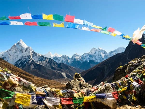
As you trek, you’ll come across several important monasteries, such as Tengboche Monastery—the spiritual center of the Khumbu region. These monasteries are not just places of worship but also hubs of local Sherpa culture. The intricate architecture, vibrant prayer flags, and the chants of monks offer a glimpse into the spiritual life of the region.
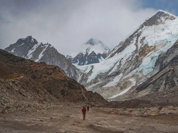
The Himalayas are home to diverse wildlife, including the elusive snow leopard, Himalayan tahr, and various species of pheasants. The natural scenery is equally spectacular, with glaciers, deep valleys, and towering peaks like Ama Dablam and Lhotse creating a breathtaking backdrop for your trek.
Every trek offers unique experiences, whether it’s the thrill of crossing a suspension bridge over a roaring river or sharing a cup of butter tea with a Sherpa family. These moments, big and small, are what make trekking in the Everest region unforgettable.


.webp&w=1200&q=75&dpl=dpl_FAQpGkN56Vgx6JRWWA11URm4YwFk)